New Mexico Land Conservancy Takes to the Skies!
The only statewide land trust in New Mexico, our work doesn’t end when the conservation easement is recorded. Every easement requires annual monitoring – a big job when you have 75 properties and counting, spread across the entire state!
So, this year, New Mexico Land Conservancy (NMLC) took to the skies with the help LightHawk Conservation Flying, a nonprofit group that connects volunteer airplane pilots with other qualified nonprofits needing their flying services for conservation purposes.
NMLC Stewardship Coordinator, Connor Jandreau, developed 4 flight plans, dividing up the state based on our easement locations, and LightHawk matched us with pilots for each area. Plane sizes vary, usually 3- or 4-seaters. Most pilots are retired people – ex-military pilots, or engineers who fly for fun. “They love to fly and they’re sensitive to conservation issues,” Connor says.
The pilots pay all flight expenses themselves – including fuel.
BIRD’S EYE BENEFITS
“Aerial monitoring provides the ‘big picture’ view, versus the micro view you get on the ground, Connor explains.“It’s a great way to look at the lands in context with their surroundings,” Connor adds. “From the air, it becomes clear how close a ranch is to, say, a mine, or a confluence of rivers. You get the upstream and downstream view, beyond the property boundaries. With aerial monitoring, you get to see how everything really is connected.” This information is helpful for our regional conservation planning because it demonstrates the important role these conservation easements play within the larger landscape.
In contrast to the one-by-one ground monitoring of every easement, every year, aerial monitoring can cover multiple properties – between 9 and 15 ranches—in one 2-hour flight, enabling us to monitor 40-some ranches this year in 4 flights – more than half our total easements.
Ideally, two staffers conduct the aerial monitoring. The property boundaries for each ranch have been pre-loaded into an iPad which is connected to GPS while flying over. One person shoots photos and directs the pilot in order to get shots of specific things. The second person, ideally the conservation project manager, can concentrate on the wider view – relationships to other natural or man-made features in the region, or the effects of fire or floods in the area.
Larger properties that consist of a single parcel, are relatively easy to monitor from the air, Connor claims. Where it gets difficult is with large ranches that have multiple easements that are not contiguous and that are situated in a complex pattern. That’s where previous on-the-ground monitoring experience is particularly helpful.
FROM THE GROUND
For onsite monitoring, “A predetermined walking or driving track through each property was established when the easement was created,” Connor explains, and this track includes “photo points” – specific spots along the track from which the monitor re-shoots photos each year for the final monitoring report. Photo points include documenting such things as property boundaries, building envelopes, and general characteristics of the land—streams, grazing pasture, or an overview from a high point on the land – ultimately to ensure there are no easement violations, which, fortunately, NMLC has never had in its 15 years as a land trust.
“It’s easy to get myopic during onsite monitoring,” Connor adds, “but it’s important to reconnect with the landowners and strengthen the relationship.”
THE FUTURE
This first year of aerial monitoring was an experiment – and by all accounts, a successful one. Aerial monitoring isn’t intended to replace onsite monitoring, but the information gathered from aerial monitoring can certainly complement on-the-ground monitoring and allow NMLC monitors to cover a lot more ground in a much shorter span of time.
“Some of our easements are tens of thousands of acres in size,” Connors says, “and in some cases, there are multiple easements in different sections of a large ranch. That’s a lot of ground to cover every year.”
We will continue to work with private landowners to increase the number of easements we hold and to fulfill our stewardship obligations—on the ground and from the sky.
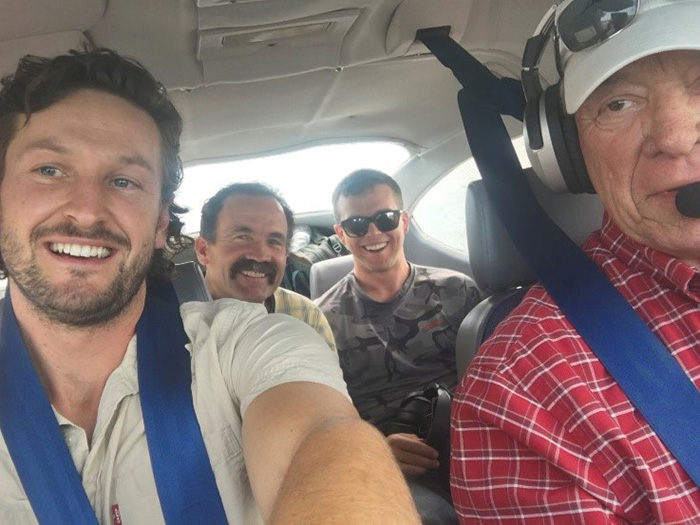
PHOTO: “Aerial monitoring gives us the ‘big picture’ view so we can see the property in context to its location, which we don’t necessarily get from monitoring on the ground,” says NMLC Stewardship Coordinator, Connor Jandreau (front left), pictured here with NMLC Southern New Mexico Project Mgr., Ron Troy (rear left), stewardship intern Jack Steele (sunglasses) and of course the pilot, Wil Worthington out of Phoenix, who donated all his expenses for the flight. Thank you, Wil and LightHawk!